|
|
 |
|
|
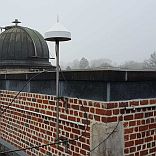
GPSBru
station UKKE (Ukkel)
| Lambert72 |
x= 149291.508 m |
| y= 165311.623 m |
| Lambert08 |
x = 649291.795 m |
| y = 665312.121 m |
| HTAW (met model hBG18) |
H = 109.355 m |
| ETRS89 geografisch |
φ = 50°47'53.75604" |
| λ = 04°21'31.32816" |
| h = 152.271 m |
| ETRS89 geocentrisch |
X = 4027859.683 m |
| Y = 307006.678 m |
| Z = 4919508.599 m |
|
| Ontvanger |
Septentrio PolarX5 |
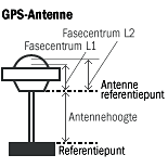
| Antenne |
Sepchoke_MC SPKE |
| Antennehoogte |
0.003 m |
| Fasecentrum
L1 |
0.0790 m |
| Fasecentrum
L2 |
0.0941 m |
| Datum ingebruikname |
09-01-2002 |
| Plaatsing GNSS ontvanger en antenne |
11-01-2019 |
| Coördinaten geldig vanaf |
03-01-2019 |
|
|
|
|
|
|
|
|